EAST TOURISM SITE:
 |
| National Park of Masoala |
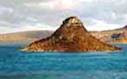
MASOALA: National Park with its rainforest wet, its lemurs and endemic birds, waters ports. Masoala is the largest National Park of Madagascar, is one of the last places in the country where the rainforest meets the sea. The Park protects the forest from the coast to the top of the mountains and three marine parks protect important coral reefs. A non-degraded shoreline and forests of great biological wealth remains to discover on the Masoala peninsula and on the forest island of Nosy Mangabe. Masoala is an excellent destination both for tourists and researchers. The Masoala National Park is the largest protected area of Madagascar, which is among the five most important countries for the conservation of biodiversity.
 |
| National Park Andasibe (Mandatia) |
ANDASIBE: National Park with the largest lemurs of Madagascar the Indri indri.
About 138 km to the East of Antananarivo by the RN2, the National Park of Andasibe is the most popular of protected areas. It actually consists of two parts: the Mantadia Park and the reserve of Indri of Analamazaotra, on an area of 16,000 ha. Visit the national park of Andasibe which is the most popular of protected areas. Treasure fauna, Andasibe is home to 11 species of lemurs including the Indri Indri, largest lemur in Madagascar can be detected by its impressive Cree. It is visible that in its natural environment as not supporting the captivity. There are also multiple species of birds, reptiles, insects and amphibians. Flora for its part is characterized by lush vegetation of tropical forest, and many species of ferns, epiphytes, sacred lianas, orchids and dwarf Palm. The Park has a center of interpretation, as well as places built in picnic sites or in areas of camping.
 |
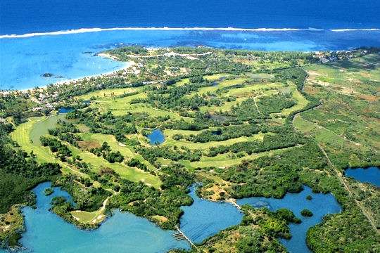
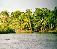
| The Pangalanes Canal |
THE PANGALANES CANAL: There is an almost continuous line of lagoons from Foulpointe to Farafangana behind its coral beaches. They are connected by artificial canals to form an inland called the Pangalanes canal. The channel Pangalanes, a 600 kilometre long lagoon formed naturally by washing sand on the island by the Indian Ocean currents and silting of rivers has been used as a means of transport along the coast and as a fishing area. Can cross the Pangalanes canal canoe of Manambato, Ankanin Ambila'ny Nofy. The Manambato village, on the shores of Lake Rasoabe, is an integral part of the Pangalanes canal. Manambato is a really charming place, one of the more attractive places in the Eastern. Visitors can relax on the Lake, go hiking in the backcountry, discover the historic site of Andevaranto, boat trips on the canal and talk about the number of fishermen.
 |
| The first port of Madagascar |
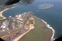
TOAMASINA: City of spices. Toamasina (commonly known as Tamatave) is the second city of Madagascar and with the presence of the main regional port has a potential for growth in economic activities. It is the largest port of the country and therefore the centre commercial of the country, a large part of the island of handling trade. You can buy vanilla in all its forms: syrup, powder, Rod, but also other spices, tons of tropical fruits: lychee, mango, guayavas, Jacquier, shells of memories or local aircraft kind made with Ravinala leaves. In the suburbs of city of Toamasina, there is the Zoological Park of Ivoloina (11 km north of the centre). He was originally an experimental garden and offers a view of the good idea of 13 species of lemurs, and a selection of the flora of Madagascar. The lemur will come eat bananas in your hands.
 |
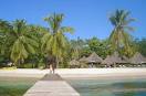
| The beautiful beach of Sainte Marie |
SAINTE MARIE: Beach rest and visit the whales in season. The island of Sainte Marie, or the island of Nosy Boraha, is Island granite close 57 km in length of 8 km off the coast of the East coast of Madagascar. It consists of a main island and several small islands. Interrupted many small villages, lush vegetation, the kilometer sandy beaches shaded by coconut trees, of its bays and coves protected by coral reefs have turned this tropical island of dream in one of the most popular beach places Madagascar. In winter (June to end of September), the sea around Sainte Marie offers one of the most natural fascinating performances of the world. Major groups (Megaptera) humpback whales make their annual migration to the Antarctic waters sheltered around Ile Sainte Marie, where they give birth, nursing their young and engage in spectacular courtship rituals. Cape Sainte Marie, beautiful beaches, cliffs of sandstone and caves provide a dream landscape at the edge of the South of Madagascar. Located between the waters of the Mozambique Channel and the Indian Ocean, Cape Sainte Marie is beaten by the winds and offers like "end of the world".
SOUTH TOURISME SITE:
TANA A ANTSIRABE: the road to the Highlands.
 |
| Hotels in Antsirabe |
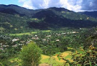
ANTSIRABE: Volcanic region and precious stones. 170 Km from Antananarivo by the RN7, the spa town of Antsirabe capital of the Vakinankaratra is surrounded by volcanic mountains and enjoys a particularly bracing climate. It became the meeting place for the patients of any Madagascar and even neighboring islands. Antsirabe that you can visit in rickshaws, has both the tranquility of a small European provincial town and a stamp typically Malagasy that we in the traditional neighbourhoods and markets. In the immediate vicinity, the nearly circular Andraikiba water the depth of which may reach 165 m. A 17 km to the Southwest, Tritriva crater of Madagascar's most famous Lake. Glucose waters have an unexplained particularity: they fall in rainy season and back in the dry season. 30 Km to the South, Mount Ibity and its orchids on rocks in a landscape uniformed. At his feet, the Valley of the Sahatany, a high place of Mineralogy. The Stonecutters of Antsirabe must to this proximity among the savvier of the island. Betafo, a small town 22 km to the West on the shores of Lake Tatamarina. His name is associated with falls of Antafofo whose waters fall 20 m in two parts in stairs in a setting in half a circus.
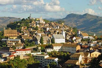 |
| The city of Fianarantsoa |
FIANARANTSOA has MANAKARA: travel by train
We speak often of Fianarantsoa and a twin sister of Antananarivo. As the capital, it has a Lake Anosy, a line of railway, the East Coast, hills and an old city. Fianarantsoa, an exceptional point of bursting in a province qualified rightly "multicolor". To the North, Ambositra door entry Zafimaniry and capital of the work of the wood. A region which does not reveal always pressed, but with many sights travelers the cascade of Andriamamovoka, an hour's walk, the Andina road and this impressive arrangement of rice terraces, and 82 km on the road of Morondava, the careers of Ambatofinandrahana marbles. To the East, Fianarantsoa-Manakara line, a train of legend revived with an exceptional momentum comes from all walks of life. 56 tunnels, 4 viaducts, and 40 other works of art, 17 distributed stations on the 170 km of a route sometimes hung in the mountains. A very notable crossing also of huge fields of tea of Sahambavy. Manakara is a city quiet Malagasy with wide paved streets and a sense of end of the world. He is known primarily as the terminus of the Fianarantsoa train line. Manakara has a few beaches lined with pine
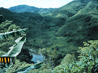 |
| National Park of Ranomafana |
RANOMAFANA: National Park with its rainforests and its lemurs is located in the Province of Fianarantsoa in South East Madagascar, approximately 2 hours by car from the city of Fianarantsoa and about 10 hours in Antananarivo. He became the Fourth National Park in Madagascar when it was opened on 31 May 1991. Rano in Madagascar means water and hot Mafana (ranomafana = hot water). About a hundred years ago a Malagasy discovered hot springs to the bottom in the Valley and the French create a spa around them. It has become the city of Ranomafana. In 1986, Hap lemur aurous has been discovered in the forest at 6 km from the city (and at the same time Hap lemur semis were rediscovered) and Dr. Patricia Wright has worked with the Government of Madagascar to create a National Park to protect species. The Park is on the edge of High Plateau of Madagascar, it is extremely mountainous, with elevations ranging from 600 m to establish. The steepness of the slopes had kept Park operation prior to 1986. The range of altitude allows many different types of forests, the tropical plain forest cloud and high plateau. The Park is divided into protected area base of 41 500 hectares surrounded by a peripheral zone in which exploitation of the forest is permitted.
 |
| National Park of Andringitra |
ANDRINGITRA: 2nd highest mountain of Madagascar 46 km from Ambalavao, to the South of Fianarantsoa. Park is attached to the Massif of Andringitra at an altitude ranging from 650 to 2658 m. the Andringitra is one of the biological sites of Madagascar, one of these natural laboratories where old species-relics and more recent species coexist by giving to the fauna or flora originality.
 |
| National Park of Isalo |
ISALO: trekking in National Park 300 km from Fianarantsoa and Toliara 240 km. Created in 1962 and main natural curiosity of the road to the South, the National Park of Isalo is chronologically the second Madagascar, and extends over an area of 81,000 ha.
 |
| Sapphire mining Ilakaka |
ILAKAKA and Sapphire deposits. The existence of gemstone minerals, including Sapphire Ilakaka mining, Sapphire rush corundum was known long in sandstones of the Isalo. The majority of the corundums from the Ilakaka area must be heated to be marketed, in fact, a stone blue, but cloudy, could not do not inevitably let suppose that its discoverers that it would become pure and transparent after a suitable heat treatment.
 |
| Tuléar the City of Sun |
TULEAR: City of Sun. On a broad coastal plain on the Mozambique Channel, endless beaches to wild thickets of the forest dry, green banks of the Onilahy River in the White Mountains; any Tuléar has been shaped by the Sun of the Tropic of Capricorn.
 |
| Anakao: the Vezo fishing village |
ANAKAO: Beach rest, Anakao is the best-known Vezo fishing village of the region. It is very appreciated by visitors for its return of fishing and the possibilities of excursions, snorkelling or diving in canoe Vezo. Surf lovers will also find their happiness. Transfer by boat for Anakao Vezo ethnic village. High performance color of hundreds of multi-colored canoes on the beach. Swimming and ride in canoe to pendulum on this vast and magnificent lagoon, visit NOSY VE and its endemic birds: straw tail. Close to Anakao, Nosy Ve Island offers a beautiful almost deserted beach. The funds will delight divers by their beauty. The island is home to a colony of birds unique to Madagascar, named phaetons with red tail. The island of Nosy Ve is also one of the only known nesting, with the meeting sites, in the southern hemisphere.
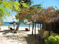 |
| The Association Reniala Botanical trail |
IFATY: Beach rest visits the botanical trail of the Association Reniala: birds, baobabs and medicinal plants; possibility of diving to see underwater and its various corals. Ifaty is the collective name given to two dusty fishing villages. South of Toliara beach is narrower and more Rocky, but the diving is a good thing. Diving, especially for sharks, is better here than in the South. In July and August, you can see the migration of whales pass. Land inside, a dry desert conduit in refined low mountains with lot of dried ground and several salt and turn off the air with a smell sulphury. The Reniala reserve is a strange thorny forest with the good bird watching and a must for wandering through the ancient baobabs.
 |
| The Mahafaly Tombs |
TULEAR A FORT DAUPHIN:
-The extreme southern coast.
-The Mahafaly tombs.
-The Villages of sinners Vezo.
-The thorny forest.
 |
| National Park of Andohahela |
ANDOHAHELA 60 km from Fort Dauphin, is a National Park of the utmost importance, which earned him to be honored with the silver Otter trophy at the 99 World Travel Market in London. Its peculiarity lies in its extraordinary variety of ecosystem due to the proximity of the mountainous chain of the Anosy.
SOUTH WEST TOURISM SITE:
TANA A MORONDAVA
-The road to the Highlands
-Barge of the Tsiribihina River descent
-Tsingy of Bemaraha strict nature reserve: Trekking in the National Park
-Morondava and its various Baobabs
 |
| The beautiful view of Kirindy Mitea |
KIRINDY MITEA 50 km south of Morondava. In the region of Belo Sur Tsiribihina in the South of Morondava, the National Park of Kirindy Mitea is located in a transition zone between the dry tropical climate and semi-arid South.
NORTH TOURISM SITE:
 |
| Vanilla Bourbon of Sambava |
SAMBAVA - ANTALAHA: planting and trainer of the vanilla. Fragrant vanilla which gave birth to the vanilla Bourbon was already cultivated in other countries before be introduced to Madagascar in 1870. The big island was already the world's leading producer in 1924; it is always with the area of the SAVA in the North is that it produces only 1,000 tones of prepared vanilla. Sambava, nestled at the mouth of three rivers in the heart of a triangle formed by Vohemar in the North, Antalaha to the South, Andapa in the West. Hiking in the Valley of the Bemarivo out of Nosiarana. Water recreation on the Lakes Andohabe and Andamoty. Its high mountains and the National Park of Marojejy. The coconut plantation of the Soavoanio covering an area over 4,700 Ha divided into 4 zones. Antalaha, its buildings of dhows, the cutting of semi-precious stones. Trekking in the Valley of the Ankavanana. Panoramic view from the weather station. Excursions to the Eastern Cape (3 hours of boat) or the Masoala Park. Vohemar, former City Islamic then destroyed by the Portuguese. Archaeological remains interested researchers. A Green Lake also called Andranotsara 7 km to the South, which would have been a former village whose inhabitants were transformed into crocodiles. Connected by a seasonal trail to Ambilobe passing through the village of Daraina gold. Andapa, in a verdant basin bordered by the massifs of Marojejy and Anjanaharibe, grenier to rice in the region. Linked to Sambava by a beautiful winding between the forest and the River Lokoho mountain road. Beautiful view on the rice plots from Anjiabe Hill.
 |
| National Park of Marojejy |
MAROJEJY: Trekking in the wet mountains in the National Park with its tropical forest. Marojejy is a surprisingly beautiful and wild of Madagascar regions. It is unique in the world, a place of dense, jungle tropical forests, pure, high cliffs and the plants and animals found nowhere else on Earth. Located in the forest tropical of Madagascar of North East between the current towns of Andapa and Sambava, the Massif of Marojejy was described by Professor Henri Humbert, the Museum of natural history of Paris in 1948. Humbert was a prominent botanist who arrived in Madagascar after exploring most of the chains of mountains in Africa. Following his expedition of Marojejy, Humbert has published a book entitled a wonder of Nature, in which he describes Marojejy as the range more impressive in all Madagascar due to its size, its rich flora and its pristine natural condition. His enthusiasm led him to ensure that Marojejy is protected as one of the strict nature of Madagascar reserves.
 |
| The town of Andapa |
ANDAPA: Bowl of rice field. The town of Andapa is located in the region of the North East of Madagascar called SAVA (an acronym for four principle towns: Sambava, Antalaha, Vohemar and Andapa). Andapa became the "rice bowl" or the "attic of rice" Madagascar in the North-East, the basin turned into large and lush rice fields. As the population increased, the hamlets tiny original grew and form a network of villages scattered throughout the fields of rice.
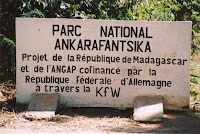 |
| National Park of Ankarafantsika |
ANKARAFANTSIKA: National Park and its dry forests 114 km is East of Mahajanga. Kingdom of birds, land of the sacred Lakes, source of life, Ankarafantsika is located to the North West of Madagascar 450 km from Antananarivo and 114 km from Mahajanga by national highway 4. Ankarafantsika is a den of birds and lemurs. A feature that made conservation a real leitmotiv for this national park; 8 species of lemurs have been observed in Ankarafantsika: a diurnal species, 2 mixed species, five typically nocturnal species including the famous Microcebus, the smallest primates in the world. 129 species of birds nest in the forest of Ankarafantsika. 75 of them are endemic. Finally, Ankarafansika is also home to local endemic reptiles: chameleons, iguanas, snakes and freshwater turtles.
 |
| The river of Antsohihy |
ANTSOHIHY: Mangrove forest. It is this type of forest stand which is always green on the coast to the North and West of the island. In general there is no surf areas but on the flat coast often flooded by the sea. At low tide the roots of support and the main root out of the water and when a flood is often that the Crown of the tree. During a trip to Antsohihy to Ambanja, can be seen a giant forest of mangroves along the national road
 |
| The Sambirano River of Ambanja |
AMBANJA: Planting of cocoa and the distillery of essential oils. The Sambirano River is the number one area attraction. The less valiant going simply by the River, in the city, to see the sleeping Sun. Coffee, cocoa and ylang-ylang plantations are still the wealth of the region. They are easy to access, to the North of the City entrance. The cocoa plantations, from huge century-old trees, produce the famous "cocoa Madagascar" that is found in the export. Try to visit a distillery of perfumed essences the passage. Ankify track time now offers a wide selection of accommodations and can therefore make a pleasant step en route to Nosy Be. The beach is beautiful and quiet. The peninsula of Ambato and Nosy Faly are wild and a little difficult to access, but it's worth the travel. It is a loaded region of history for the Sakalava people and can attend ceremonies.
 |
| National Park of Ankarana |
ANKARANA: National Park with its Tsingy, dry forest, cave at approximately 100 km of Antsiranana and Nosy Be. Born under the sea millions of years ago, the Ankarana including 18,000 ha were converted into Park extends its network of caves, underground rivers and canyons in dry and green forests. BALY 150 km to the South West of Mahajanga. 150 Km to the South West of Mahajanga, the Bay of Baly is still little known by tourists but did not long remain so!
 |
| Mountain of Amber |
MOUNTAIN of AMBER: National Park with its rainforest wet. Mountain of amber is a stamp isolated mountain forest that rises from the surrounding region of dry. The Park is famous for its waterfalls, crater Lakes and wildlife. Mountain of amber is located near Joffreville (Ambohitra), 27 km to the South West of Diego Suarez (Antsiranana). Joffreville, a former retirement of French officers who are now in a State of disrepair, is the entrance to the Park. Mountain of amber is composed of Montane forest, deciduous wet and dry tropical forest. It has large runways and areas of camping and is characterized by the wind and cool, becoming even very cold at night.
 |
| The three Bays of Antsiranana |
DIEGO and its three bays of Antsiranana, located at the extreme north of Madagascar, called Diego Suarez until 1975 and Diego even called by many, is the capital of the Province North of Madagascar. It has one of the most beautiful ports in deep water in the world, complete with a photogenic sugarloaf mountain. Visitors usually like this city, which is probably the most French city in Madagascar. It was this colonial feeling over it. It is the largest city in the North with a huge comfortable market, a range of excellent Restaurants and some fantastic places and national parks to visit nearby. Diego is the perfect place to drag and to prepare for the visit of the district. A dozen kilometres of Diego, we borrow Sandy 5 km trail that will lead us to the three bays. Will known for their wild beauty, this succession of bays of Sakalava, Pigeons and finally Dunes dazzle you by long beaches of white sand and turquoise sea. We finish our loop exiting by the Camp of Orangea to reach the village of back. We will see the beautiful sunset.
CENTER TOURISM SITE:
 |
| Antananarivo Capital City of Madagascar |
Antananarivo (Tananarive) is the capital city of Madagascar and the largest city on the great island of the Indian Ocean. The town is located inland, about 90 miles from the East Coast. Antananarivo was founded in the early 1600 and its position on top of a high ridge made easy to defend against enemy attack. Antananarivo means "the city of the thousand", a reference to 1000 soldiers who itself saying protected the city newly created under the reign of King Andrianjaka revered. In 1895, the French have taken over and expanded considerably to include many new buildings and roads. Madagascar won its independence from the France in 1960. Today, Antananarivo has a population of about 1.4 million people. Will it surprise you with its rice fields, pollution, and Asian appearance, many stairs of the steep hills, palaces, the cobbled streets and churches. This is not Africa or Asia, Madagascar is totally unique.
Travel to Antananarivo:
 |
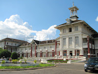
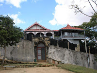
| Palace of the Manjakamiadana Queen |
Most of the people who travel to Madagascar will arrive in the capital since the International Airport of Ivato. Antananarivo is a place bustling with many churches, a mosque, a Zoo and a lot of markets. The capital is essentially built on 12 hills and steep steps led to the main square of independence in the City Centre. The architecture is a mixture of old houses wooden, modern offices and French colonial-style buildings. The best way to see Antananarivo is walk and takes taxis. Many visitors take a taxi to the Manjakamiadana Rova in the upper town and walk from there. Zoological and botanical Tsimbazaza Park is home to some of the unique flora and fauna including the lemurs of Madagascar. It is fairly typical of many cities in developing countries: many of poverty, pollution and infrastructure ruin dotted with modern cafes, restaurants and shops selling Western products.
 |
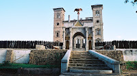
| Palace of the Ambohimanga |
THE SACRED HILLS: A total of 12 which has always been unanimously, however a list who has known many variants according to the sources. The most famous: the set of 3 hills forming Analamanga, original site of Antananarivo. Ambohimanga hence went the conquests of Andrianampoinimerina, listed world heritage of the Unesco. Ilafy North of the capital where King Radama II liked to withdraw with his playmates. Ambohidrabiby where, around 1600, King Ralambo introduced in uses Zebu meat consumption. Antsahadinta South West, trees "Amontana" symbol of royalty and "Aviavy" symbol of nobility, its numerous hiking choices. Following the national road. On the RN1 leading to the volcanic region of the Itasy, the Lemurs'Park and 9 species of lemurs reintegrated in an enchanting setting. Antongona Hill at the entrance to Imerintsiatosika with on the top two Royal squares transformed into museums. On the RN2 or road of Tamatave, Ambohimalaza historic village famous for its immense necropolis and its topped tombs of a cabin or "Tranomanara". Nandihizana level, the Massif of the Angavokely bifurcation offering one of the most beautiful panoramas of land plants. Ambatolaona, access recommended for Mantasoa, its Lake, its hillsides dotted with charming cottages, its historical remains. The Gorges of the Mandraka from PK 62, where the road switchbacks literally dives in a grandiose setting of beauty.
 |
| Fall of the Lilly |
On the RN3, Anjozorobe and its forest corridor, very popular with birdwatchers because with the advantage of also having an aquatic avifauna.
140 Km to the North West by the RN4, the special reserve of Ambohitantely, consisting of a forest natural relic where Royal Palm endemic Tampoketsa of Ankazobe throne.
On the RN7 Finally, complex of recreation and crafts of Analamanga Park 30 km from the capital, marking the boundary South of the area